She didn’t tell her parents until after the flight. She didn’t want them to worry.
Looking out her window, she could see the plane was wrapped in thick, gray clouds. It was loud, too. The sounds of the computers and the murmurs of conversation among the other passengers were layered on top of the roar of the plane’s propellers, which cut through whipping winds that climbed to 180 miles per hour.
Assistant Professor Deanna Hence was flying into a hurricane.
It was September 2005, and Hence—a grad student with only one year of study behind her—was on a Navy Research Laboratory P-3 flying into Hurricane Rita. Scientists were busily working around her as she focused on the screens of data. Her adrenaline was pumping, and she could see everything was falling into place—she would be able to collect all the data she needed for her thesis.
Hurricanes are big. Hundreds of miles wide. After hours of traversing the storm, the rain soon stopped pelting the windows of the plane and the blanket of thick clouds fell behind them. They had reached the eye of the storm.
Above them, the sky was open and blue and clear and quiet.
Around them, the angry clouds formed angled walls, much like the bleachers in a stadium rising up in a V from the field.
Below them, the waves of the ocean grew to huge swells, crashing into one another in a frenzy of whitecaps and sea spray.
Smack in the middle of the calm sky and the angry clouds and the frenzied waves was Hence. She felt her heart breaking because she knew what came next. All the scientists did. It was only weeks after Hurricane Katrina left massive devastation in its wake, and the region was still reeling from the disaster.
All the excitement and thrill of flying into a storm and watching the data roll in was matched with the somber understanding of the power this storm had to upend lives. All these things existed at one time: the blue sky and the flooding rains, the thrill of the adventure and the pain for the loss to come.
The calm and the chaos. The person and the scientist.
It is hard to separate the two.
Flying toward the red
Write down a list of the most adventurous careers, and atmospheric scientist may not come quickly to mind. It is true, however, that many of these scientists find themselves in perilous circumstances. They fly into the hurricane and drive up to the tornado. And while they’d admit the adrenaline boost is exhilarating, they are motivated by more than just the challenge of facing nature’s fury.
They want to save lives.
The more intimately we understand storms, the more robust our warning systems can become.
“I have always been motivated by the desire to try to decrease suffering, to help people be resilient,” said Hence.
With more data, we can also create more effective disaster response plans and build infrastructure that can withstand ever-worsening weather, saving billions in rebuilding lost property.
Atmospheric science is an old field. Humans have always tried to explain the phenomena around them. In the 20th century, however, two events radically propelled our understanding of weather—the first was the rise of aviation, especially during WWII. Military pilots were making some of the first observations at high altitude, helping us understand the atmosphere in ways we didn’t before. The second was the evolution of computing, giving us the opportunity to calculate, model, and predict at high speed. And now in this century, we’ve seen an explosion of Earth observation from space. Each of these revolutions in science bring us closer to understanding, but there is still so much more to know.
“There’s a lot that we still only partially know about how clouds work,” said Hence, who studies cloud dynamics and cloud physics. “How do crystals form? How does the air motion within them lead to different events happening? Until we have a solid understanding of how those processes work, it is going to be extremely difficult to replicate that accurately in a model.”
In the end, observation is key. Sometimes the best way to understand something is to get as close to it as possible.
As Hence remembers a Navy crew member saying to her, “Y’all are the only crazy people who fly toward the red on the radar.”
Thunderstruck
On a drizzling afternoon in late April, Professor Steve Nesbitt parks his Prius right next to the yellow-cladded pole barn in Research Park where the Doppler on Wheels (DOW) is stored. He’s brought along Professor Jeff Trapp, head of the Department of Atmospheric Sciences and Lina Rivelli Zea, a doctoral student who came to Illinois from Paraguay.
The two men unlock the building, and each slides open a massive barn door, like game show hosts parting a curtain to reveal the grand prize.
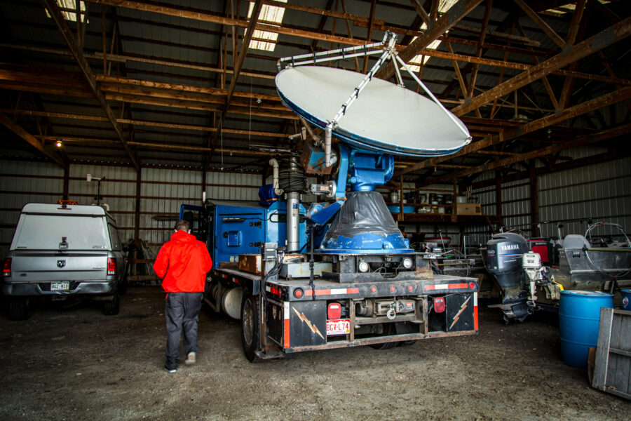
Inside the barn are fishing boats and rain barrels, a dusty red International Harvester tractor and window screens leaning up against the wall. Parked in the middle is the DOW, its radar dish stretching nearly to the wooden rafters.
Zea starts up the DOW and allows it to warm up before carefully backing it out and parking it in a field right next to the barn. She leaves it running, and the noise can only be described as a deep, guttural growl causing us all to strain our voices to be heard over the sound.
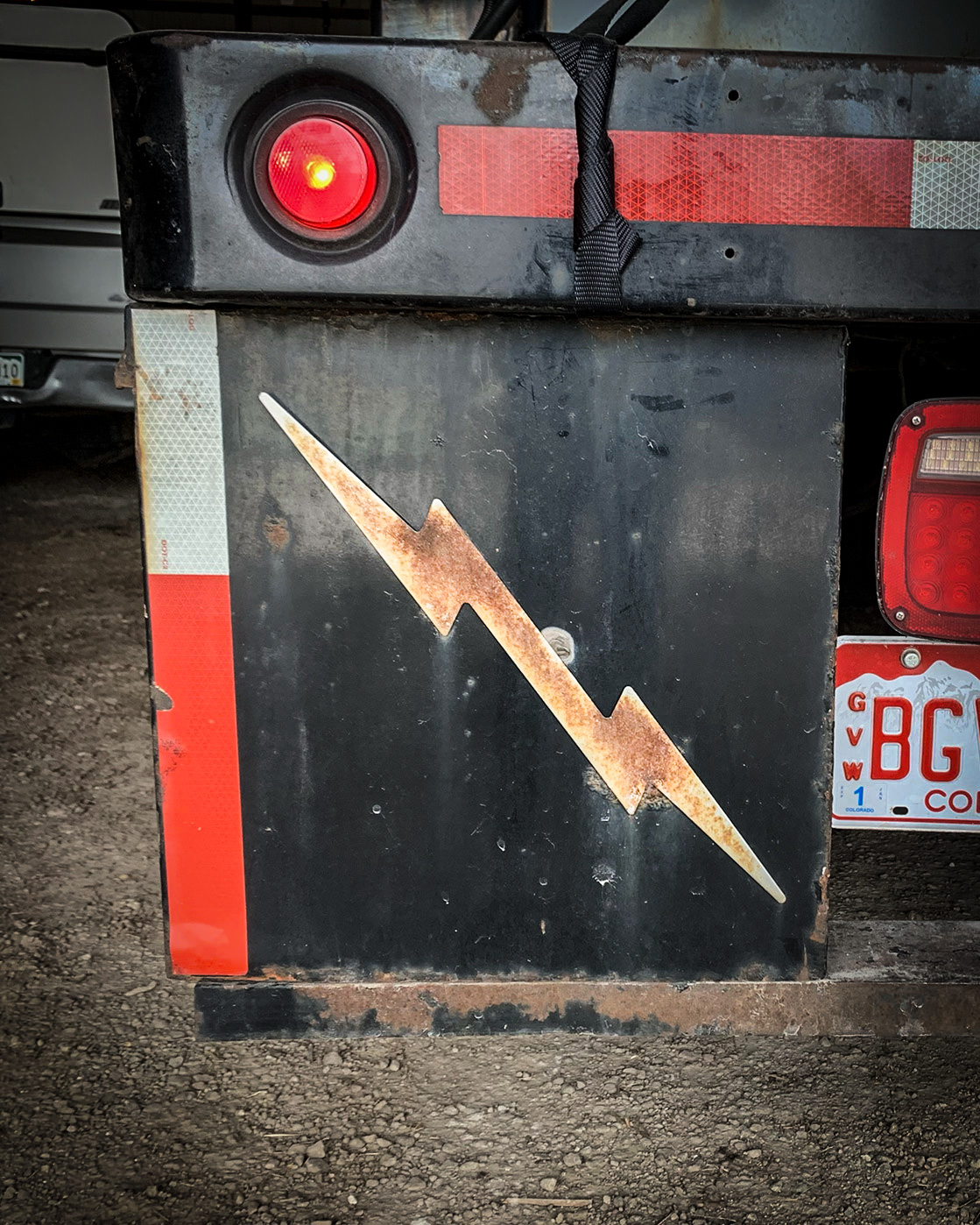
I am eye-level with the flatbed of the truck that holds the radar dish, generator, and antenna which was made with WWII scrap metal. Blue duct tape circles the bottom of the radar and gold lightning bolts adorn the mud flaps.
It is a tough looking machine. The DOW wears its rust not as a sign of decay, but as a badge of honor. After 170,000 miles, it could tell some remarkable stories.
This is one of a small fleet of mobile radar trucks that Illinois scientists use to study storms around the world. This particular DOW collected data during Hurricane Laura and was shipped to Argentina as part of Nesbitt’s RELAMPAGO field campaign, the largest U.S. campaign conducted outside the country.
The first mobile weather radar was built in 1995 by Josh Wurman, formerly a professor at the University of Oklahoma, and now an adjunct instructor for Illinois. Wurman may be a familiar face, having been featured in Discovery Channel’s Storm Chasers.
Through our partnership with Targetable Meteorological Systems, Illinois is the only university in the country whose students have dedicated access to DOWs for classroom instruction and research projects. “We’re going to have a record number of incoming students this year, in part because of this equipment,” Trapp said.
This DOW, now rumbling in an open field, is a third-generation design. These trucks were built to get as close to the tornado, wildfire, cyclone, or blizzard as possible so that scientists can collect data that other radars and satellites just can’t get. The closer the observation, the better the data. The better the data, the better the models. The better the models, the more accurate our predictions.
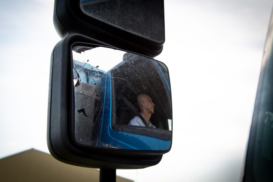
And while cozying up to a tornado, for example, definitely has its risks, Nesbitt explains that the risk is actually much lower than we realize. “Once the tornado forms, we know what it’s likely going to do. What we don’t know is precisely where or when it’s going to form. So, a lot of times, the most challenging thing is the wait. You’re all juiced up, you’ve got your equipment ready, you hope it’s going to work, you’re sitting in a gas station or somewhere and you’re waiting for things to pop.”
The DOW is always in communication with an operation center who helps the crew know where to drive. Once they are on their way, the adrenaline kicks in. Sometimes they throw on music.
AC/DC’s “Thunderstruck,” of course.
“We’re watching the data, making sure the equipment’s working, trying to fix problems,” says Nesbitt. “Sometimes, there’s a leak in the roof or something and you’re duct taping the windows or you’re out there kicking something to make it work or you’re trying to fill a weather balloon and it blows up accidentally.”
Ultimately, though, there is an emphasis on safety. The most anyone has been hurt is was when one scientist got appendicitis. “We don’t put people in danger. We really try to make sure that there’s almost no risk to people,” says Nesbitt.
That doesn’t mean the DOW doesn’t take a beating, however. “In Argentina, one of our radars got hit by baseball-sized hail. Fortunately, the hail didn’t ruin it. But it definitely has some kisses on the antenna.
Seeing inside the storm
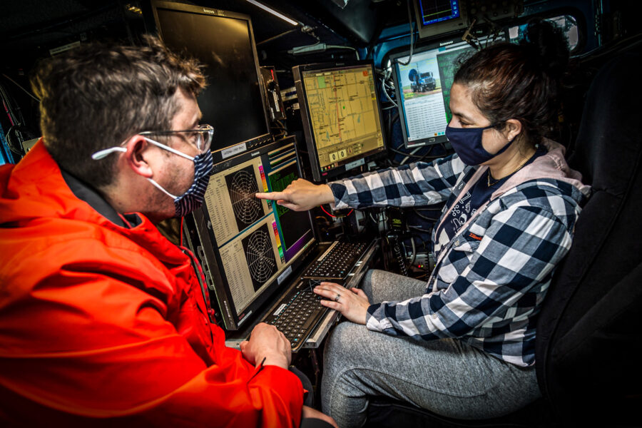
Inside the DOW, Zea sits in a gray, worn captain’s chair. She swivels in tight quarters from left to right as she explains how the team monitors the multitude of screens. Usually two scientists sit in this part of the DOW running the radar, spinning the antenna, and collecting samples. They can read the shape and size of raindrops, the amount of rainfall, and the speed and direction of the wind.
Zea laughs as she remembers her first time in the captain’s chair. She compares it to learning a new language. As much as it is learning about engineering and meteorology, it is about learning to work in a team. In addition to the two scientists in the back of the DOW, the team includes the driver and the navigator who is constantly monitoring GPS and National Weather Service data.
In the middle of lightning and hail and torrential rain, they have to work together to launch weather balloons and scan the radar and navigate as close to the storm as possible. To do that, the team members need to be in sync. “We have to understand each other in order to be precise and get good data,” she said.
It is exhausting and intense work, but, as Zea said, “On a mission, the feeling is incredible.”
The data that the DOW is able to collect is providing a new perspective on what we know about storms—with the goal of minimizing damage and saving lives. According to Trapp, we are able to see more detail than ever in our data collection. He likens it to the evolution of digital cameras. What once provided a discernible but not terribly detailed image, is now so clear that we are able to distinguish characteristics of storms we were never able to before.
This clarity is incredibly important to the quality of weather modeling. “Storms are doing a lot within the atmosphere. They take heat from near the ground and push it up to the top of the atmosphere, and then back down again. If we can’t represent that process with the rest of the processes in the atmosphere, something is missing. The way to do that is to use a high-resolution model so that we understand the heat mixing and the rain formation,” said Trapp. “It not only allows us to have better forecasts now, but it also translates to what we want to think about in the future.”
Right now, faculty are using modeling for a wide variety of projects, including to predict the future global climate by taking current and historic storms and placing them in a simulated future climate to determine how the storm might evolve and what damage it might do. Will a high-impact event such as a tornado outbreak, for example, become an even higher-impact event? One faculty member is even using modeling to study…modeling, and how to resolve disagreement between models.
Of course, research isn’t only relegated to computer models or data collection from the Hurricane Hunter or the DOW. Part of a meteorologist’s fieldwork often includes surveying the damage after a storm and talking with residents who were affected. How much warning did they have? How was their property damaged? Studying structural damage is a large component of figuring out how big a storm is. But, more importantly, this very human experience of connecting with residents in real time brings the devastating impact of severe weather into sharper focus.
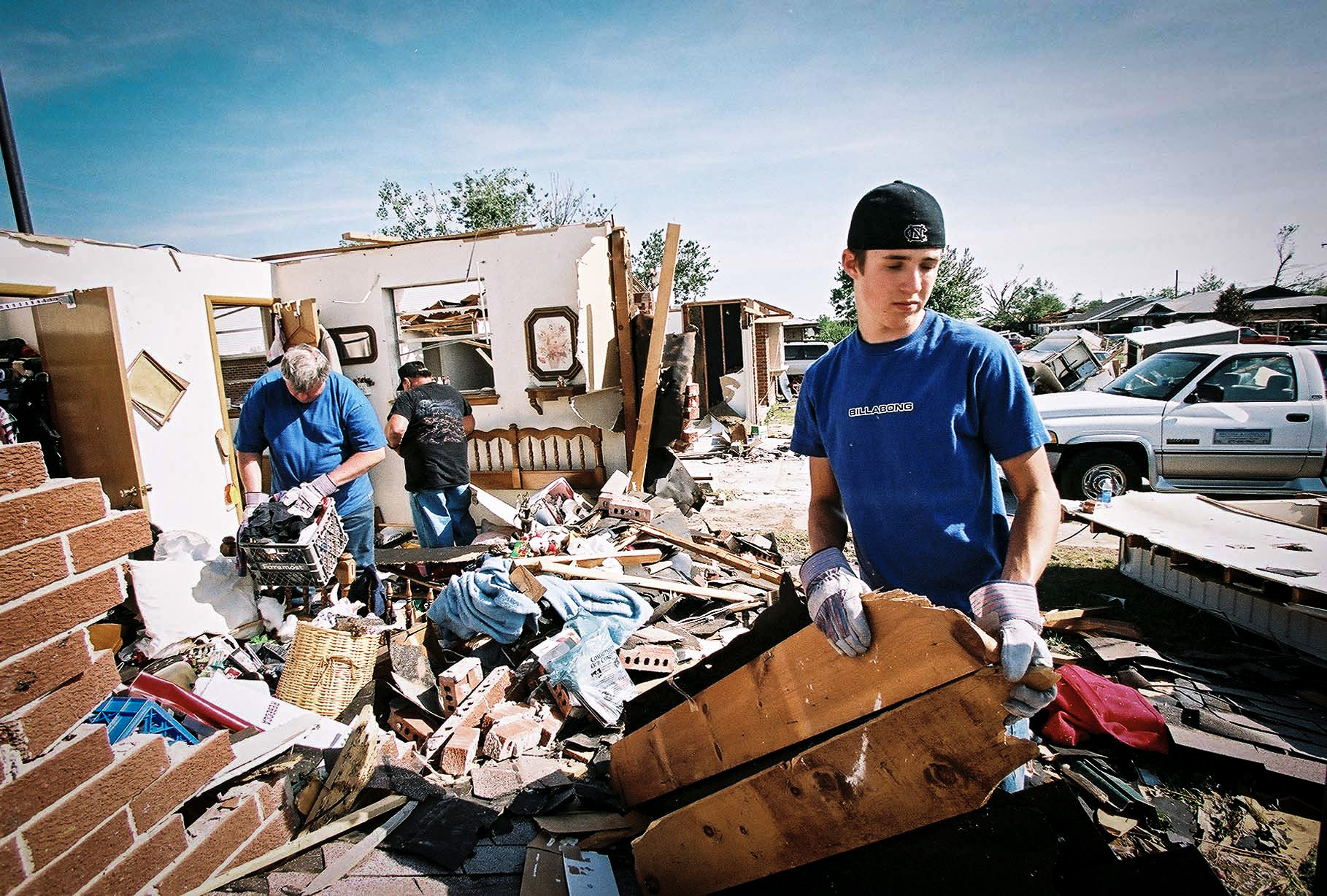
In 2013, Trapp was doing fieldwork with a team in Oklahoma, about thirty miles from the city of Moore when an F5 tornado ripped through the town. At its widest, the tornado spanned over one mile wide on the ground, with winds topping 210 miles per hour. Because the tornado swept right through a populated city, the devastation was enormous: twenty-four people lost their lives and over 200 were injured. Just like Hence felt flying into Hurricane Katrina, Trapp felt a pit in his stomach watching the storm pass over the city on the radar. “It’s a frustrating feeling, too, because this storm was well predicted, and yet still people lost their lives,” he said.
After the storm passed, Trapp and his team traveled into Moore to talk to the residents.
“The experience is something that all meteorologists, especially anyone who chases storms, should have,” said Trapp. “It gives a deeper appreciation of the impact of the phenomenon that we’re trying to study.”
The human dimension
Faculty in the Atmospheric Sciences department have done research all over the world—Nesbitt has done research on five of seven continents—all with the aim of increasing global understanding of weather and storms. As our climate changes, storms worsen and become more frequent. Rising temperatures and sea levels bring new challenges to communities.
This makes our partnerships with scientists around the world critical.
“As a scientist, you think you’re going into a project to collect data points and analyze the data. But really, the more rewarding part is understanding the impact of weather on people around the world and how it differs from here,” said Nesbitt. “Meeting and working with the community of scientists around the world who see things in a different perspective than we do is really rewarding,” says Nesbitt.
Partnerships with community members is vital to the science, too. “The boots on the ground are the people who have observed these things over and over again. They have sensed the dangers and the risks,” says Nesbitt.
And, according to Nesbitt, it turns out that the anecdotal weather data is pretty good. “If you ask somebody how big a hailstone was, they can give you a good idea. Residents can also measure impact well. They can say, well, forty years ago the water was twenty feet from the surface but now it’s only ten feet down, for example. That kind of data is really useful, and it helps us actually design some of our campaign. We can use it to generate our own scientific questions.”
Nesbitt believes science is one of the most effective tools of diplomacy. In fact, meteorology was one of the first places where international agreements were made. Science in general and atmospheric science in particular, has unique potential to provide a mechanism through which people around the world have to come together to work on issues that affect all of us.
Partnering with those who make policy decisions is key to making sure scientific knowledge turns into actionable policy. And so, while our faculty continue to push further into observational meteorology, they are also building partnerships with social scientists and policymakers and exploring scientific communication and public education.
“Increasingly, we are partnering with social scientists in our research, bringing in those experts in the beginning. That is becoming part of the DNA of our fieldwork,” says Trapp.
Hence is also expanding her research to include the social impacts of weather. “From a young age I was always interested in the human dimension of things,” said Hence. “Right now, my research is looking at the role of extreme weather events in infectious diseases, how intense convective storms impact crop damage, things like that, so I can help inform research around building sustainable cities and infrastructure.”

The goal of saving lives is woven into our faculty’s research. Building the strongest bridge between science and policy is paramount to achieving that goal. And because much of our scientific enterprise is federally funded, it is important to make sure that knowledge is shared equitably. During Hurricane Katrina, for example, many Black and Brown communities were disproportionally affected by the storm.
“Federally funded science needs to serve the taxpayers. All of them, not just a select few,” says Hence. “One of the hardest things [about Hurricane Katrina] was having to watch thousands of Black people suffer, thousands of Black people die—despite the fact that we had excellent forecasts, despite the fact that the science showed very clearly that we had to get people out as quickly and efficiently as possible. There is more to trying to save a life from a natural hazard than simply knowing and understanding how that phenomenon works.
“The reality that scientific knowledge did not help stave off that outcome on its own, made me realize that excellent science isn’t enough.”